Go to Page
July 27th 1839.
Dear Sir,
Having escaped from Connamara and the twelve Pins, I now proceed to notice the (barony of) Moycullen. It consists of three parishes, viz Kilcummin, Killannin and Moycullen, of which (the two former), Kilcummin and Kilannin anciently formed the territory of Gno-mor and the latter, Moycullen, was a part of the territory of Gno-beg.
OF THE PARISH OF KILCUMMIN
Situation. This parish is bounded on the north by Joyce's Country; on the east by Lough Corrib many of whose islands it embraces; on the south by the parish of Killannin, and on the west by the parish of Moyrus in Connamara.
Name. The name of this parish is in Irish Cill chuimin which means the church of St. Cuimin, who was according to tradition, the original founder of the parish. I here transcribe what O'Flaherty wrote on the places in the places [sic] in this parish, and become his scholiast.
The Barony of Moycullen, ({which is}) commonly known in Irish by the names of Gnomore on the north, Gnobeg on the South, is separated on the north from Joyce Country
by a ridge of mountains and Lough Orbsen; on the east it lyes by Lough Orbsen and the River of Galway; on the south by the Bay of Galway, and hath Ballynahinchy barony on the west.
On the north side is the River Failmir(a) and another river; they both meet in one channel before they come into Lough Orbsen, and have two different kinds of trouts, which come from the lake to the common channel, and they are seen to separate one from the other as they go on their distinct rivers, so as the kind of the one is never found on the other.
The River of Fuogh falls from the mountains through steep rocks till it passes by the castle of Fuogh(b) to Lough Orbsen Eastward. It was(c) com-
[NOTES BY JOHN O'DONOVAN]
(a) This river, as I have observed in a former letter, falls into the Bealanambrack river a short distance to the east of O'Rourke's Hotel at Ma'am.
(b) This castle was totally destroyed to build the barracks of Oughterard. It stood at the natural bridge on Mr. French's part of the townland of Fuagh. This castle is mentioned in an Inquisition taken in the reign of Eliz: and (in) another in the reign of Car I. q.v.
(c) This is the River which flows through the town of Outerard. It is still called the Owenriff - Abhainn Roibh - or Sulphur river, which is the name that should be adopted on the Ordnance Map. When it dries up in Summer, which often happens, sulphur is observed on the stones in its channel.
monly called Owen roivhe (Abhainn Roibhe) or Brimstone River, the occasion of which name was but lately discovered by an extraordinary drought of weather 1666, 1667, wherein there was brimstone found on the dry stones about the bridge of Fuogh. On this River is salmon fishing, and muscles are found that breed pearls.(d) On the north side of the River not far from the Bridge westward, was discovered by revelation about the year 1654, a well(e) in honor of St. Michael, archangel. From this River to Galway, about twelve miles(f) there is indifferent good (arable) land by the lake and river of Galway on the east(g) of it and the mountains on the west between it and another tract of land by the sea side. Near Fuogh is the parish church of Killcumin(h) and St. Cumin's
[NOTES BY JOHN O'DONOVAN]
(d) They find some of them still.
(e) This well is still shewn near Calligan's hotel in Outerard. It should be shewn on the Ordnance Map, but it is not set down in any of the name books.
(f) The reputed distance is 14 Irish miles. O'Flaherty reckoned by the big Connaught miles! magnis milliaribus Conaciensibus. See Hibernia Dominicana, p. 308 note e.
(g) The Country from Galway to Outerard is now truly beautiful and picturesque.
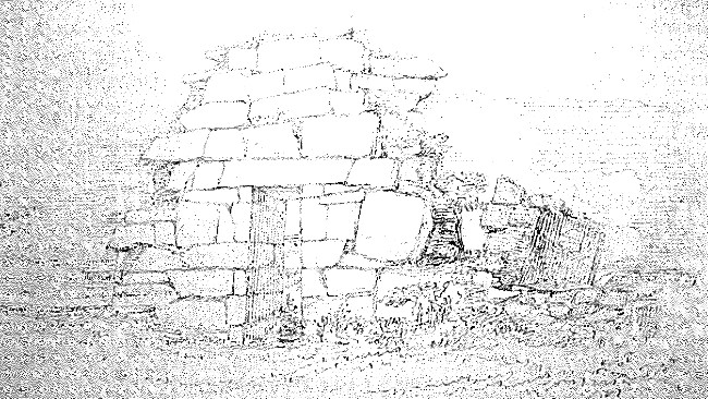
(h) The ruins of this church are still to be seen near Lemonfield house to the right of the road as you go from Galway to Oughterard. There is no part of the original church of St. Cummin now remaining, for the present building is certainly not older than the beginning of the 14th century, if even so old. It is about 60 f. long and 18' 0" broad. The east gable is perfect and contains a window which is broad on the inside and gradually narrows Continued on MS P. 144.
well, where he is worshipped as patron of the parish {on the 14th}(i) of October.
[NOTES BY JOHN O'DONOVAN]
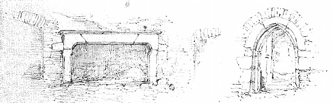
towards the outside. On the outside it is 5f. 0in. high and 11 inches broad (wide) and on the inside 6f. 4in. in height and 4f. 0in. in breadth. This church consisted of two wings, the northern (one) of which is totally destroyed, but the southern is in a good state of preservation. It is about 13f. square. A pointed doorway (5' 8" high and 3' 10" broad) leads into it from the body of the church, and in the south wall of it is rather a neat window in the round but modern style. The west gable of this church is nearly destroyed, and of the north wall there remains but a fragment 20f. 0in. in length and 10' 0" in height. The north and south walls, within 3f. 6in. of the N.E. and S.E. corners contained each a window which is now formless. The doorway was in the south side wall not far from the west gable, but it is now so injured that I could form no idea of its dimensions or characteristics. There is a large cemetery attached to this church in which many of the ancient and modern families of the district are interred.
(i) The words in brackets are supplied from the present usage in the Country St. Cummin's well, called in Irish Tobar Chuimin, is situated in a field nearly opposite O'Flaherty's gate at Lemonfield. The natives of the district still hold it in the highest veneration, and whenever they pass by it they take off their hats and make a slight bow to it. During the rage of the Cholera in 1832 the people dwelling in its vicinity peeled off the bark of ancient ash trees which grew over it, to use it as a remedy or antidote against the cholera; after which the trees decayed rapidly and were prostrated by the memorable storm of last January.
Can any reference to St. Cuimin of Gnó mor who was revered on the 14th October be found in any of the Irish Calendars? He must have been a distinguished [sic] from a deep respect with which his memory is still honoured.
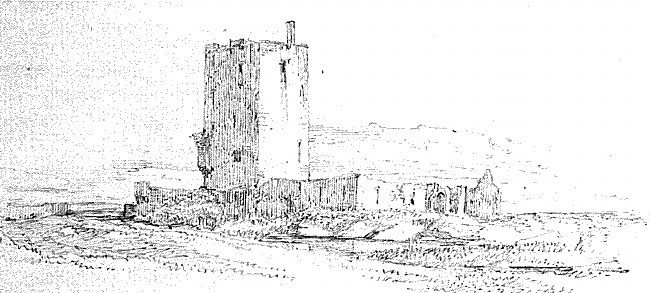
Not far from thence is the castle and manour of Aughnanure,(j) where the salmon comes under the castle on a river not far from the west side of Lough Orbsen.
[NOTES BY JOHN O'DONOVAN]
(j) Burke in his Hibernia Dominicana confounds this place with Lemonfield in the townland of Cower from which it is two miles distant. The name is written by the Four Masters and by (Mac Firbis in the pedigree of) O'Flaherty Achadh na n-Iúbhar, which signifies the field of the yews. One of these yews still remains (on the west side of the castle) but it is fast decaying, it having been nearly cut through with a hatchet by some countryman, who wished to steal it. The name is locally interpreted Ford of the yew but the word Achadh, for the meaning of which we have the authority of Adamnan, always means a field never a ford. A similar mistake in the translation of Achad ur in the County of Kilkenny has been committed, the name being now translated to Freshford instead of Freshfield.
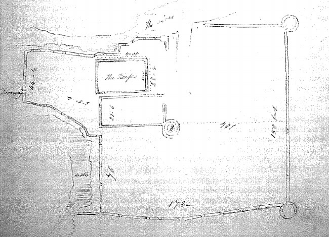
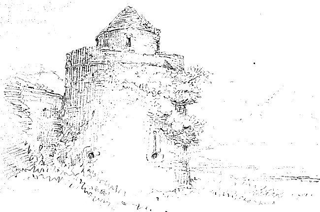
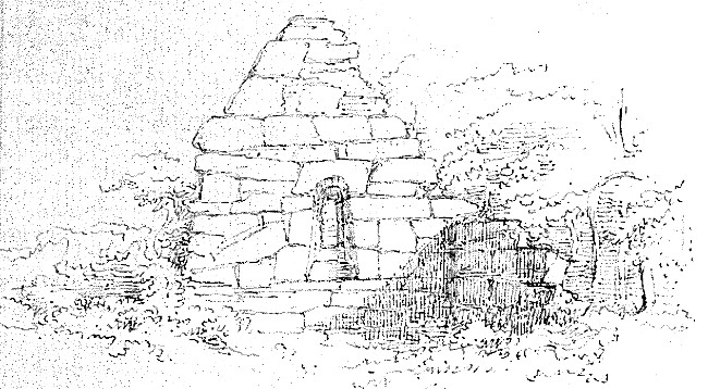
The Castle of Aughnanure, which is a fine specimen of an Anglo-Norman Castle was, in all probability, built by the Earl of Clanrickard, for it appears from the Memoirs of Clanrickard that the great Earl Ulick of 1641 lived in it, till he was beat out of it by Sir Murrogh na dtuagh O'Flaherty; but the O'Flahertys will not give Clanrickard this honor. It is a square tower 36f. by 27 (the walls of which are 4 feet thick) and six stories high. It is surrounded by strong walls which are defended by round towers. The south side of the external wall is about 210 feet in length, and on the east side 162 feet. See a plan of this castle in page ? Continued on MS P. 146.
[NOTES BY JOHN O'DONOVAN]
Not far from this castle to the west is the church of Killeroon, said to have been built by O'Flaherty's after expelling the priests from a chapel which they had at Aughnanure. It is evidently modern and contains no feature worthy of description. Its name is not set down in any of the Name books. It belongs to the parish of Killannin.
The Parishes of Kilcummin and Killannin are (so irregular and) so much insulated in each other that my best plan is to transcribe O'Flaherty's account of the whole barony of Moycullen, or the greater part of it, and to add in notes what the places are now called, and what remains there are at them.
(k) Killanhin signifies the Church of St. Anhin, who is said by tradition to have been a female saint, but no certain historical account of her has been yet discovered
(l) This well is still well known under the name of Toberannin {Tobar Ainthín or Tobar Aithnín}. It lies in the townland of Killannin, and is marked even on Larkin's mark of the County of Galway.
(m) (The name) Loughlonan is no longer remembered in the Country. It is the lough now called the lake of Ross, as can be proved from its contiguity to St. Annin's church and well. See a description of Killannin in p. ?
(n) This castle is nearly destroyed, but a small portion of its ruins are still shewn on an island in the Lake of Ross. The (village and) townland of Ohery or Oaghery in the parish of Moycullen still retains its name.
The next parish of Gnomore is Killanhin, but Killanhin(k) parish church is in Gno beg, where the memory of St. Anhin Virgin is celebrated the 18th of January, and where her well(l) is frequented on the north east brink of Lough Lonan.(m) This lake lies between Gnomore and Gnobeg, and there is no recourse of water from it but under ground. On an island thereof is the castle of Ohery.(n)
From the River of Spiddle,(o) which separates the parish of Moycullen here from the parish of Killanhin on the west of it to the River of Ally(p) are two miles, and in the middle way is the creek of Crompan,(q) a very secure harbour for boats much frequented by the fisherman of Galway. Ally River divides Gnobeg on the east from Gnomore on the west in those parts;(r) whence to Cromlin is two(s) miles; not far from which westward, {on the} 3rd of June 1682, was a fish cast on Miny shore(t)(t) 30 feet long and 7 high. Near Miny is the castle of Inverin(u)
[NOTES BY JOHN O'DONOVAN]
(o) The River of Spiddle is 9 miles west of Galway. It flows out of a lake in the townland of Shannagarraun, and falls into the bay of Galway nearly opposite Ceann Boirne or Blackhead.
(p) Now Abhainn na hAille, so called from the townland of Aylle or Aille through which it flows. It is exactly two miles due west of Spiddle.
(q) Crompaun is the Irish word for a creek, or Pill.
(r) This shews that Gnobeg comprised more than the parishes of Rahoon and Moycullen. It extended from the River of Galway to this river of Ally and from the Bay of Galway to the northern extremity of the Lake of Ross {- anciently Lough Lonan -} so as to comprise the old church of Killannin.
(s) From the river of Aille to the River of Crimlin {Cruimghinn} is now reckoned 3 Irish miles. The River of Crimlin falls into the Bay of Galway between the townlands of Poulgorm and Cartronkeel. There are two portions of the parish of Kilcummin here insulated in the parish of Killannin
(t) Miny is now always called Minna.
(u) The castle of Inveran stood over a little Bay (creek) from which it takes its name about 2½ miles from Casla Bay on Blake of Drum's Estate.
where Walter Fada Burke was murdered by the procurement of his stepmother Finnola Flaherty by her brother Donel Fitz Rory oge Flaherty, Anno 1549 deceased. Thence westward at Moerras(v) (.i. Moyrus) is an altar of St. Columbkille by (i.e. hard by) a brooke, and his well within the sea shore. His feast is celebrated on the 9th of June.
From Cromlin River to the River of Cashla are two(w) miles. This river falls into Casla haven, and hath salmon and trout-fishing on it yearly. These white trouts are called Dihain,(x) and come on the river from the sea as salmons do. On Casla
[NOTES BY JOHN O'DONOVAN]
(v) I cannot find any place (now) bearing this name, but the Down Survey calls the townland verging on the (east side of Casla Bay by the name of Moyrish). There is a burial ground called after St. Columbkille in the north west of the townland of Cloghmore on the east side of Caslah Bay. This altar of Columbkille near the brook, and his well at the shore should be shewn on the plan of Killannin parish. The Moyrish of the Down Survey comprises the Cloghmore and Keeraunmore of the Ordnance Map.
(w) From the source of the river of Crimlin in the townland of Bobrickaun to Cashlah Bridge is not much more than 2 large Connaught miles, such as O'Flaherty reckoned, but from the mouth of the River Crimlin in a direct line to the mouth of the River of Cashla, that is, where it falls into the bay (of Cashla) is more than 4 Irish miles.
(x) Called now in Irish -
Haven in the year 1674 memorable for dearth of corn through all Ireland, the herring fishing of Galway Bay failing, (another) herring fishing was discovered and so continued for 5 years after and failed again. They were larger and sooner come than Galway fish.
There I saw a herring 18 inches long.
Between Casla(y) haven and Fear mor,(z) or the Great man's haven, lies the land of Killin(aa) about 4 miles ({ long?}), where stands the church by the seaside which antiquity named Innis Macaw(bb) church, the feast day whereof is on the 15th of March. Westward of Great man's
[NOTES BY JOHN O'DONOVAN]
(y) This bay is always called in Irish Cuan Chaisle, the Bay of Caushlia, but in English they are beginning to call it Costello Bay from an idea that it may have been named after the family of Costello, but it was not; and we must adopt the name Casla Bay on the Ordnance Map as the most analogical anglicising of its original Irish name.
(z) This Bay lies directly west of Casla Bay, there being a peninsula about 2 Irish miles in breadth between them. It is called Cuan an Fhir Mhóir in the annals of the Four Masters at the year 1600, which is the name still in use among the Cois fhairge people, but those who speak English always call [it] "The Great Man's Bay". Of this great man tradition remembers nothing more than that he was one of the giants who lived here so long ago that no one knows how long, and who plundered all the boats and ships that passed the way. The natives still point out a large hollow rock called his churn - Cuinneóg an Fhir Mhoir - and three large rocks called Brannaidh an Fhir Mhóir, which supported the three legs of his pot in which he Continued on MS P. 151.
haven are the lands of Garmna,(cc) Lawchoill,(dd) and Letter-mellan* Castle. In Garmna is Oilither church,(ee) or the pilgrim's church; Keann-Gualaim or the Cape of Golam head stretches itself between Cape in haven and the sea, the furthest end of Moycullin barony this side and is 8 leagues from Galway. Eastward of this point the isles of Aran be 3 leagues distant from the continent of this barony, whereof Lettermellan is the nearest to them.
[NOTES BY JOHN O'DONOVAN]
was used to boil the whales caught by a fishing rod! He was equal to Rabelais giant. I firmly believe in his existence, though I have no historical evidence to prove the period at which he lived, or whether he was one of the (Fomorians or of) Bolgic or Danaan colony.
(aa) [Referred to on MS p. 150] The townland of Killeen forms the southern part of the peninsula lying between Casla Bay and the Great Man's Bay
(bb) [Referred to on MS p. 150] This church is now called Teampull Ins' Mac Adhaimh (Macáimh) ([Added in pencil:] Temple Inish Macaw) i.e. ecclesia insulae filorum Adami ([Added in pencil:] Macami). It lies in ruins on the west side of Casla Bay close to the shore. Is there any reference to this church in any of the Irish Calendars at the 15th of March. It belongs to the territory of Gnó mór.
(cc) Garmna, now generally called Garomna is an island lying between the Great Man's Bay and Caisin Bay or Cuan Chaisin.
(dd) Lawchoill is now called in Irish Leamh-choill, i.e. Elmwood & anglicised Laughil. It forms the southern portion (part) of the island of Gorumna. In the Life of St. Einné, this place is erroneously said to be in the Great island of Aran, but I suspect that the error is to be attributed to the editor, not to the author of this life. See my remarks on the Aran islands.
(ee) This church is still in existence but its name is not set down in any of the name books. It is shewn on the Down Survey and even on Larkin's Map of the County of Galway.
* The Castle of Lettermellan is mentioned in the Annals of the 4 Masters
at the year ([Added later] no!) ? Its site should be marked on the Ordnance Map. The fishermen on Aranmore told me that no part of it now exists, and I therefore did not go (to) see it.
O'Flaherty in speaking of the islands in Lough Corrib has some notices of islands belonging to the parishes of Kilcummin and Killannin:
Lough Orbsen so called from Orbsen Mac Alloid one of the Danann nation, a very spacious and large lake, hath its source at Bunbannon in the half Barony of Rosse, and extends thence 8 miles eastward to the river of Cong, having the half barony of Rosse, partly on each side, partly dividing Rosse from Moycullen Barony, and partly having Rosse on the north side. It extends southwards 12 miles in length till it discharges itself into the River of Galway, having the Baronies of Kilmaine and Clare on the east, and the Barony of Moycullen on the west; somewhere 4 miles in breadth, and sometimes less than a quarter of a mile.
It is said to have as many islands as there are days in the year all of them belonging to the west as far as where a boat can pass between them and the east side.(a) Of these Inisquin and Inismictrir contain a quarter of land each; some half a quarter, some a cartron, some an acre, and most of them but few acres. On that island of Inisquin,(b) St. Brendan built a chapple {ejus vita 16th May Cap 59} and worked divers miracles. In the same island St. Meldan, whose festival day is on the 7th of February was abbot of a famous abbey about the year 580. He was spiritual father to the great St. Fursey(c) of Peronne in France {Vita St. Endei Mar. Cap. 2, 5} who carried the reliques of that saint along with him and enshrined them at Peronne.
[NOTES BY JOHN O'DONOVAN]
(a) The same is said at this day, but still many of the islands belong to the barony of Clare on the other side.
(b) Now called Inis Uí Chuinn. This island is so celebrated that the whole lake is sometimes called Loch Inse Uí Chuinn from it. See my letters on the parishes in the Barony of Clare.
(c) See my account of the church of Killursa in a letter from Tuam.
The Isles of Lough Orbsen were pillaged Anno 927 by the Danes of Limerick.
Echinis, or Horse island, now Innis-gearan(d) or garron Island, the same in sense as Horse-Island, lyes very near Eanach Caelain(e) continent, but nearer Ard,(f) part of Aughnanure, is an Island where St. Enna of Arran visited St. Coelán, priest on Lough Orbsen. This St. Coelan is worshipped (venerated) the 25th of April. Of him likely Enagh-Coelain nigh Aughnanure, is named. ({Not far from this}) Innis- Flannan,(g) an island which retains the memory of St. Flannan, patron of Ballindun parish. ([Note in left-hand margin] Some defect in text.)
{He next speaks of Inchagoill, but as I have quoted all he says of it in my letter on that Island, I deem it unnecessary to transcribe it here}
Iniscreawa (Inis Creamha), or Wild Garlic isle, is near Cargin, in the barony of Clare, a small island where the walls and high ditch of a well fortified place are still extant and encompass almost the whole island.
[NOTES BY JOHN O'DONOVAN]
(d) This name still exists, but it is not set down in the name Books. It lies in Lough Corrib not far from the Castle of Aughnanure.
(e) Now Annaghkeelaun near Aughnanure castle.
(f) Sic hodie. It is near the castle of Aughnanure.
(g) Now Inishlannaun, an island in Lough Corrib belonging to the townland of Gortnashingaun.
Of this island, Macamh Inse Creawa (Macámh Inse Creamha),(h) a memorable ancient Magician, as they say, had his denomination.
Anno 1225. The Lord Justice of Ireland, coming to the port of Iniscreawa, caused Odo O'Flaherty, Lord of West Connaught, to deliver that island, Kirk island, and all the boats of Lough Orbsen into the hands of Odo O'Conor, King of Connaught {Cathal Redfist's son} for assurance of his fidelity. Anno 1233. Fedlim, King of Connaught, brother to the former demolished the castle of Kirk Island, Galway, Hag- Island, and Dunoman (.i. Dunamon near Athleague).
{He next speaks of the Three Earls, who took shelter under the humble Roof of a farmer of the name Murtough Boy Branhagh ([Added in pencil:] {Walsh}) on the west shore of this lake, of which see a former letter.}
[NOTES BY JOHN O'DONOVAN]
(h) This island belongs to the Barony of Clare and lies in Lough Corrib opposite the Castle of Cargins. See my letter on the parish of Cargins.
This lake breeds salmons, eels and several sorts of trouts, especially the delicate lough trout of which kind there were two by chance catcher! (.i. caught) that had fair golden spots. It distributes the salmons among divers surrounding rivers which mutually contribute their fish and their waters to it, and every salmon, if not hindered will be sure to go to that river where it was first engendered, and after spawning there returns in due season to the sea. Here some old seals come along from the sea in pursuit of the salmons.
Here is another kind of fish which hath recourse to the sea as the salmon yearly to and fro; they are called chops, and in Irish Trascain very like herrings, only that herrings come not in fresh water.
OF THE PARISH OF MOYCULLEN
Situation. This parish extends in length from Lough Corrib to the Bay of Galway. It is bounded in the west by the parish of Killannin; on the north and north east by the parish of Killannin and Lough Corrib; on the east by Lough Corrib and the parish of Rahoon, (and) on the south by the bay of Galway.
Name. The present name of this parish is Magh Cuillinn, which would mean the plain of the holly, but O'Flaherty, in his Ogygia and Statistical account of West Connaught, shews that the original name was Magh Uillinn, the field of Uillinn, who was one of the Tuatha de Danann colony. This was Roderic O'Flaherty's patrimonial inheritance, and the manner in which he speaks of the loss of it in his Ogygia is truly affecting and worthy of (a) Job.
Orbsenius mercator erat negotiationibus inter Hiberniam et Britanniam tractandis insignis; Manannan Mac Lir vulgo dictus; Manannan ob commercia cum Mannia insula, et mac Lir i.e. mari satus ob nandi atque urinandi peritiam; quod portuum quoque discrimina apprimè calleret; ac aeriae
praescius vicissitudinis a tempestatibus praecaveret. Succubuit vero in proelio apud Moycullin in margine spaciosi lacus Orbsen qui per Galviam fluvium in sinum Galviensem exoneratur, ab Ullino Nuadi regis Hiberniae per Thadaeum filium nepote confossus. Pugnae loco Ullinnus, laco Orbsenius nomen indidit; de his ita Flannus a monasterio (ex poemate Eistígh a eólcha gan ón).
Do chéar Mac Allóid go n-ágh an minn mór gharg Manannan
As an (.i. is in) chath ag Uillinn Chruaidh; do láimh Uillinn abhradhruaidh.Occidit Alladii proles generosa Manannan
Ullinno Ullinni manibus certamine victus.Magh Ullin igitur Campus Ullini, in quo scilicet congressus est, parva mutatione fit Moycullin. Locus hic natalitius meus fuit, et longa atavorum serie patrimonium. Mannerium erat regiis diplomatibus a regio vectigali exemptum, fori et nundarum privilegio dotatum, ac Curiae quam vocant Seneschalli, libertate ad dirimendas lites honoratum. Infra bimatum vero patre orbatus minorennis patriae legibus in tutoriam regis custodiam deveni, et nummos, ut mos erat, pro tutela numeravi: sed antequam ex lege per aetatem licuit haeredita-
tem adire, tutoris praesidium amisi regis mei parricidio undevigenti annos natus, et regius haeres semestri me junior peregre victum quaerere compulsus est. Regium haeredem Dominus bonorum omnium applausu citra pulverem et sanguinem ad sua regna mirabiliter revocavit: Sed me non dignum invenit, cui tugurii mei regnum restituat; Sit nomen Domini benedictum in aeternum.
Ogygia part III, p. 180.
Correct Translation. Healy's is very incorrect.
The merchant Orbsen was remarkable for carrying on a commercial intercourse between (Britain & Ireland); he was commonly called Manannan Mac Lir; Manannan from his commercial intercourse with the isle of Mann,(a)(a) and Mac Lir, i.e. the son of the sea, from his expertness at swimming and diving; because he was well acquainted with the dangers of harbours, and because by his skill in the changes of the weather he always avoided storms.(b) He fell in battle at Moycullin, on the margin of the spacious lake Orbsen {which discharges its redundant waters into the Bay of Galway by (or thro') the river Galway,} being stabbed by Ullin, the grandson of Nuada king of Ireland by his son Tadhg. The site of the battle was called after Ullinn, and the lake after Orbsen. Concerning
[NOTES BY JOHN O'DONOVAN]
(a) See William Sacheverell's account of the Isle of Mann p. 20 where he writes Mannan Mac Lear whom they believe the father, founder and Legislator "of their Country".
(b) As an authority for this O'Flaherty might have quoted Cormac's Glossary in which the following notice is given of Manannan:
Manandan Mac Lir .i. cendaidhe amhra bhoí i n-Inis Manand. Ba hé luamaire is dech boí i n-iarthar domhain. Ro fhindadh tria nemghnacht {.i. gnáthúghadh, in nimhe} in oiret (.i. airet) no beith in t-soininn ocus in doininn, ocus in tan nós claechlóbhadh cechtar de (.i. nae) air ré.
Inde Scoti Britonesque eum Deum vocaverunt maris, et filium maris esse dixerunt; et ab eo Insola Manannan dicta est, i.e. Manann an Mac Lir, a famous Merchant who was in the Isle of Mann. He was the best navigator in the west of the world. He used to discover by observation of the heavens when there would be good or bad weather and when either would change by the moon. Hence the Scoti and Britons used to call him the God of the Sea, and they said that he was the son of the sea. From him the isle of Manann is named.
these Flann of the monastery thus writes:
Mac Alloid of prowess fell
The great fierce chieftain Manannan
In the battle at hard Ullinn
By the hand of Ullinn of the red brows.Magh Ullinn, therefore, the plain of Ullinn, in which the battle was fought, by a slight change is made Moycullin. This is my natal soil and patrimony through a long series of ancestors. It was a manor exempted by a patent from royal tribute, endowed with the privilege of holding a market and fairs, and honoured with the liberty of a Seneschall's court to settle litigations. But having lost my father before I was two years of age, I came under the tutelary protection of the king by the laws of the country regulating minors, and paid, as was the custom,(c) money for my wardship; but before it was lawful for me by age to enter upon the enjoyment of my patrimonial inheritance, I lost the patronage of my guardian by the (regicidal) execution of my king in the nineteenth year of my age, and the royal heir {the Prince} half a year younger (than I), was forced to seek refuge in a foreign country.
[NOTES BY JOHN O'DONOVAN]
(c) This was called the Law of Wardship and Livery, which was abolished at the restoration of Charles the II. When any estated gentleman died leaving an heir in the age of minority, the King took the estate into his own possession and enjoyed the profits of it till the heir was of age, but he was obliged to pay a certain sum, proportioned to the extent of the estate, for the education of the minor. When O'Flaherty was 19 years of age Charles I (whose ward he was, according to law), was beheaded, and the territory of Gnobeg, the patrimonial inheritance of O'Flaherty then in the King's hands, was (soon after) apportioned by Cromwell among his followers. It appears from the act of Settlement that Note continued on page 161.
The Lord has wonderfully restored the prince to his kingdom by the consent of all good men without contention or blood; but he has not found me worthy to be restored to the kingdom of my cottage. Against thee only, 0 Lord, have I sinned; Blessed be the name of the Lord for ever.
[NOTES BY JOHN O'DONOVAN]
the townlands comprised in Gno-beg were given to the Martins of Galway and other families. The townland of Park in which he lived now belongs to Robert Martin of Ross.
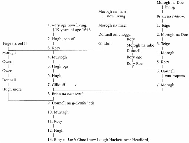
Duald Mac Firbis states in the abstract of his genealogies drawn up in the year 1666 that Rory oge of Moycullen (then living) was the lawful heir to the chieftainship of Gno-beg in West Connaught. He gives his pedigree:
[NOTES BY JOHN O'DONOVAN CONTINUED]
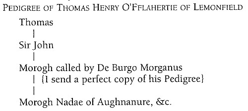
[In left-hand margin, beside pedigree chart: The other branches of this family now respectable are O'Flaherty of Knockbaun a very respectable gentleman; O'Fflahertie of Kilkenny, the next heir to Lemonfield and P. O'Flaherty of Aran, who never married; Mr. O'Fflahertie of Oughterard the Postmaster and High Constable is supposed to be the representative of the family of Moycullen.]
A most melancholy description is given by the antiquarian Molyneaux of Roderic's circumstances in the year 1709. The following are his words, which show how little he sympathised with his brother antiquary.
Wednesday the 21st of April 1709.
I went to visit old O'Flaherty, who lives very old in a miserable condition at Parke some three miles west of Galway in Hiar or West Connaught. I expected to have seen here some old Irish manuscript[s], but his ill fortune has stripped him of these as well as his other goods, so that he has nothing now left but some few pieces of his own writing and a few old Romish books of History printed in my own life {time}. I never saw so strangely stoney and wild a country! I did not see all this way three living creatures, not one house or ditch; not one bit of corn, nor I may say - one bit of land(!!) for stones; in short, nothing appeared but stones and sea; nor could I conceive an inhabited country so destitute of all signs of people and art as this is yet. Here, I hear, lived multitudes of barbarous, uncivilised Irish after their old fashions, who are here one and all in defence of one of their own or even any other rogues that fly to them against the laws of Note continued on page 163.
[NOTES BY JOHN O'DONOVAN]
Ireland, so that here is their assylum. Here is committed the most barbarous murders after shipwrecks and all manner of rogueries protected that the sheriff of this county scarce does appear on the west side of Galway bridge, which, tho' Ireland is now generally esteemed civilised may well be called the end of the English Pale, which distinction should still have place as long as the inhabitants live without in an open state of nature.
Molyneaux, the real savage, here gets vexed with the manners of the people, of (whom) he tells (us) he saw no one at all! (perhaps it was with the manners of the stones). For he says he did not see three living creatures {not even seagulls!}. Such a savage as he was would form the same opinion at this day of the inhabitants of Connamara, but he would indeed be very much mistaken.
In his account of West Connaught O'Flaherty has the fOllowing notice of Moycullen:
Gnobeg contains the parishes of Moycullen and Rahun. The three first parishes ({Kilcummin, Killannin and Moycullen}) lie in length from Lough Orbsen to the bay of Galway, and Rahun from the River of Galway to the same Bay. The castle and manner of Moycullen, whence the parish and barony of Moycullen are named hath Lough Lonan ({Now lake of Ross, JO'D}) on the west, Tolokianls two castles next adjacent on the north, and Lough Orbsen on the east (now called the Castles of the Two Sisters; one of them was blown down by the storm of last January. The townland in which they are situated is now called Tullokeeaun). The parish church thereon, its chief feast of late is the immaculate conception of our Blessed Lady on the 8th of December as patroness. What ancient patron it had is unknown.
Here Uillinn, grandchild of Nuad Silverhand, king of Ireland 1200 years before the birth of Christ, overthrew in battle and had the killing of Orbsen Mac Alloid, commonly called Manannan Mac Lir; Manannan, the Mankish man (Manann-án), Mac Lir, son of the sea, for his skill in seafaring. From Uillinn Moycullin is named, to wit, Magh-Ullinn, the field of Ullinn, and from Orbsen Lough Orbsen or the lake of Orbsen. Six miles from a great stone in that field {erected perhaps in memory of that same battle} to the town of Galway
He gives the following curious description of that part of the barony of Moycullen (lying along the bay Of Galway) including the Southern part of this parish.
The tract of land on the south side of the barony by the Bay of Galway, divided among the four parishes and separated from Lough Orbsen and the river's tract by a large space of mountain land, is good pasture for cattle, but so craggy and full of stones, and so destitute of deep mould that in very few spots of it a plough can go, yet the tenants by digging, manure it so well, that they have corn for themselves, their landlords(a)(a) and markets. Never was a garden more tilled for black seeds.(b) They carry on horses out of the shore all the seaweeds cast in daily as long as they can get it from Michaelmas
[NOTES BY JOHN O'DONOVAN]
(a) They paid the landlord in kind at this period.
(b) q? what? not in Johnson's Dictionary.
till sowing time past, and sometimes in Spring tide low water they go as far down as they can, man, woman and child, and cut the sea weed with knives to have it cast up again by the sea. With this they muck(c) the land and dig up daily earth to cover it out of watery furrows which serve for conveying away the water from the ridges. This mucking and digging keeps them in action till March, before which they sow not a grain of corn till March (seduardant, JO'D). In sowing they give so small a measure of seed as can be imagined, being sure not a grain will fail to multiply. In Summer when it grows up they go man, woman and child, and lie prostrate or sit upon the corn, and weed it with their bare hands leaving nothing behind them but pure corn. Twice perhaps they thus weed it before it comes to an ear. The soil bears not but for two years till they muck it again. The first year it bears wheat, barley, ry (.i. rye) or oats;(d) the second year oats only, but the increase is fortyfold at the least. Here is a
[NOTES BY JOHN O'DONOVAN]
(c) muck was then used to signify manure. "It is usual to help the ground with muck, and likewise to recomfort with muck put to the roots; but to water it with muck water, which is like to be more forcible, is not practiced." Bacon's Natural History. The Irish use this word to signify a pig. To muck is used as a verb by Tusser.
(d) No Potatoes at this period! The first Crop in this district is now always potatoes, the next wheat or oats, but they sow very little wheat here now.
kind of corn they called bwagh;(e) the grain is like wheat but more brownish and swarthy, the bread like barley bread but finer. Two bushels of this corn is three bushels ground.
This land hath no help for building but thatch and plenty of rude stones that cannot be wrought. It is destitute of wood, and lime stone, few places having any clay for mortar. It hath several little brooks and rivers falling from the mountains to the sea which bear some salmons, trouts and eels, besides plenty of sea fish and shellfish, together with several creeks and harbours. There is a shift for making lime of the shells for making leather.
Now to descend to particulars. In this tract near Galway westward is the townland of Barna(f) very good arable land where partly the plough, partly digging with the spade is used. It affords limestone and clay. Here is Blake's hill(g) over the sea whither the young men of Galway were wont to come on horseback the third of May ({to celebrate?}) their May game, and there dine between the hill and the castle of Barna. Sir Morogh O'Flaherty of Aughnanure defeated an army out of Clanrickard the 22nd June Anno Domini 1564 (1664?) on the Strand of Traybane.(h) This strand yields
[NOTES BY JOHN O'DONOVAN]
(e) I have met no one here that ever heard this word applied to any kind of corn. I fear that there is some error in the transcription. The words now in use are cruithneacht, wheat; coirce, oats; eórna, barley; seagal, rye.
(f) Now Barna in the parish of Rahoon.
(g) It retains this name still. Is it shewn on the plan of Rahoon Parish?
plenty of cockles and with a drudge oysters are to be found in it. Westward from thence, and from Galway 4 miles, the river of Forbagh(i) runs to the sea; near which was a great fish cot (.i. caught) anno 1667/8, another about a mile thence at Koylagh(j) the 17th of May 1674, 30 feet long and 7 feet high. Two miles from the River of Forbagh to the River of Spiddell on which the salmon cannot pass a steep salmon leap a mile from the Bridge, on the mouth of the River, first built anno 1670 by the public charges. On the east side of the River by the high water mark of the sea stands the church of Spiddell dedicated to St. Enna,(k) patron saint of Arran, whose feast is kept the 21st day of March. Spiddell is so called of Spittle(l) or Hospital. From this River which separates the parish of Moycullen here from the parish of Killanhin on the west of it, to the River of Alley are two miles.
See p. 8, line 1, Killannin Par.
[NOTES BY JOHN O'DONOVAN]
(h) [Referred to on MS p. 166] Now Tráigh Bán Trawbaun, the white strand in the parish of Rahoon. Is it on the plan?
(i) Now pronounced Furrobagh. This river rises in a lake in the townland of Knockalougha and flowing through a Townland of the same name falls into the bay of Galway.
(j) Now Killough in the parish of Rahoon.
(k) See a description of this church in p. [?]
(l) This is an old English word for hospital still used in Scotland.
To the Spittle go
And from the powdering tub of infamy
Fetch forth the lazarkite of Cressid's kind.Shak[e]speare.
See also Spittle fields, Dublin, and see p ? for a description of Spiddell.