Go to Page
July 22nd 1839.
[Added in a different hand:] Recd. augt. 29th
Dear Sir,
The last parish in Conmaicne Mara which I visited is Moyrus, and to that I now turn my attention. This parish forms the southern portion of the territory of Conmaicne mara, or Conmaicne, the maritime, and is bounded on the North west by the parish of Ballindoon; on the north by the parish of Ballynakill; on the north-east by the barony of Ross; on the east by the Barony of Moycullen, and on the South and South west by the Atlantic Ocean.
Name. - Moyrus is an Anglicising of the Irish Magh Ruis which means the plain or field of the point or promontory, a name truly descriptive of the land on which the ancient church of the parish stands.
Conformably with the plan, which I originally adopted, I shall transcribe what Roderic O'Flaherty wrote about this parish in 1684, and become his Scholiast, and this is the
safest plan to adopt as he omits nothing of importance and he lived at a period when tradition was many degrees more vivid than it is at present.
Having thus surveyed the three isles of Aran as in a sea parenthesis(!!), I will hence steere my course from the point of Golam head, the furthest point this side the west continent {of the west continent I touched} to the Barony of Ballynahinchy.
The Barony of Ballynahinshy known in Irish by the name of Conmhaicne mara {i.e., the sea Conmhaicne to distinguish it from Comnhaicne Rein containing Angaly (i.e. Annaly) in the County of Longfort and Muinter Eolais in the County of Leitrim; {from} Conmhaicny Dunmore now the barony of Dunmore in the County of Galway, and {from} Conmhaicny Culy, now Kilmayn barony in the County of Mayo} is divided into the south and north half baronies; and on the east side lyes adjacent to the Barony of Moycullen, washed by the western ocean on the south side and north coast of it till it meares with the mountains of Joyce's Country on the North-East.
On these coasts amber grease is frequently found.
The present inhabitants of Connamara never found or heard of such a thing being found. - J.O'D.
In the {year} 1666 there was a great quantity of black amber cast ashore every where, and (but?) the people not used to the like knew it not, yet they could get 10 shillings an ounce for it when people understood what it was. The best is of the colour of Castile soap, and worth 70s. an ounce.
Here are some spots of fine arable land by the sea side almost every where, and when that is wanting they work with the spade. The country is generally commendable for fishing, fowling and hunting. No river there towards the sea, and scarcely any small brookes (are) without salmons, white trouts and eels. Many waste islands here during the Summer season are all covered over with bird eggs far more delicate than any laid by poultry. Here is a yearly a great slaughter made of seals,(a) about Michaelmas, on wild rocks and waste islands of (i.e. in) the sea. Many lands here invironed for the most part by the sea are called Irros(b) with an adjective to distinguish them one from another.
[NOTES BY JOHN O'DONOVAN]
(a) They never slaughter seals now, and it is very seldom they kill any of them. They believe that a number of the Conneelys were metamorphosed into seals!
(b) See my letter (written at Binghamstown) on the meaning of the word Iorros, in which I have come to the conclusion that it means border, margin or brink.
Between the cape of Golam head,(c) and Mason head, the Ocean breaking into the Haven of Cassin(d) separates the barony of Ballynahinchy from the barony of Moycullen. The coast hath several banks of scollops and oysters whereunto Inverglassen(e) River parting both baronys falls. The next land on the west of it is Irrosainhagh,(f) a small country and therein the lands of St. Kieran's church,(g) and hill, named likely from St. Kieran of Cluain mac noise, St. Enna's disciple, worshipped the 9th of September.
[NOTES BY JOHN O'DONOVAN]
(c) Now often called Golden head by those who speak English, but always Ceann Gualaim in Irish. It lies immediately to the west of Lettermullen. Mason head is always called Ceann Mása in Irish, i.e. the head of the land called Maus or Mace.
(d) Now called in Irish Cuan Caisin but it is generally and not incorrectly anglicised Casheen Bay. It lies to the north of Golam head.
(e) Inverglassen is now called the Invermore River. It forms a considerable part of the boundary between Gnomor and Conmaicne mara.
(f) Now called distinctly in Irish Ionras Aintheach. It is the name of a small district, and cannot, I fear, appear on the Ordnance Map.
(g) Now a townland situated in the South-east end of the parish of Moyrus. The name is in Irish Cill Chiarain, and in English, by established custom, Kilkerran, so called from a little church (on those lands) dedicated to St. Kieraun, near which there is a holy well called Tober Kieran, (a name) which I do not find in the namebooks.
Over against Mason head in the same country lies Cruach Mhic Dara,(h) a small island and harbour for ships. This island is an inviolable Sanctuary dedicated to Mac Dara, a miraculous saint whose chappell is within it, where his statue of wood(i) for many ages stood till Malachias Queleus, Archbishop of Tuam caused it to be buried under ground for special weighty reasons.
[NOTES BY JOHN O'DONOVAN]
(h) See a description of the ancient church of Mac Dara on this island on pages 23, 24, (25) [i.e. MS pp. 134-6]. This saint is still held in the highest veneration among the marines of these western coasts, who celebrate a "pattern" in honor of him (annually) on the 16th of July, on the shore opposite his island, and in the town of Clifden. Many of the fisherman are still called after him. I met two with his name on Aran more, viz Mac-Dara Costello, and Mac Dara Mac Donogh. They also call (some of) the boats after him, which, in my opinion, is strange enough, as (according to O'Flaherty his real name was Sinnach.) This puts me in mind of a most extraordinary superstition still deeprooted in the minds of all the fishermen of Galway, Aran and Connamara: they cannot bear to hear the name of a fox, hare, or rabbit pronounced(!), and should they chance to see either of those animals living or dead, or hear the name of either expressed before setting out to fish in the morning, they would not venture out that day. This is a most unaccountable superstition! and still the real name of their great patron is Sionnach, a fox! They never however mention that name, for they know it not, but always style (the saint by) his patronymic (of) Mac Dara.
On the shore of this island is the captive's stone where women on (i.e. at) low water use to gather Duileasg for a friend's sake in captivity, whereby they believe he will soon get succour by the intercession of the saint. Duleasg or Salt leaf
[NOTES BY JOHN O'DONOVAN]
(i) [Referred to on MS p. 116] This is amazingly curious. Pity that one does (not) know the spot where the good Archbishop buried this effigy, to have it dug up and preserved as a monument of antiquity! Giraldus Cambrensis states that in his time there were many wooden effigies of the primitive Irish saints preserved in the churches of which they were the (original) founders and patrons {insert his words here} and I have seen two of these effigies his oculis: (the) one on Inishmurry off the coast of Sligo, and the other on Inis Gluaire off the Coast of Erris-Downan; the one is an effigy of St. Molash, the patron of Inishmurry, and the other that of St. Brendan, the patron saint of Inis Gluaire. See my letter from Sligo in which I abuse the swaddlers for stating that the effigy on Inishmurry was the figure head of a ship.
The bishop Queleus above mentioned by O'Flaherty as having buried the effigy of St. Mac Dara, is the very famous Archbishop of Tuam who sent Colgan a list of the churches and chapels of the archdiocese shortly (nuper) before the year 1645.
De Ecclesiis autem harum insularum, ac primò primae insulae, earumque patronis aliisque sanctis sequentia accipe ex Elencho Ecclesiarum Diocesis Tuamensis {in quâ jacet} nuper nobis transmisso, et fideliter scripto per Illustrissimum Dominum Malachiam Quaeleum {O'Cadhla} [In left-hand margin: Keighly] Archiepiscopum Tuamensem, virum religionis zelo eximium et omni virtutum genere ornatissimum, prout jacent excerpta.
Acta SS. p. 714, Col. 2.
is a weed growing on sea rocks, and preserved by drying it on stones in fair weather, and soon after when occasion serves for eating; there is scarce any sea shore {on which} it grows not.
The boats that pass between Mason head and this island have a custom to bow down their sails three times in reverence to the saint. A certain captain of the garrison of Galway anno 1672, passing this way and neglecting that custom, was so tossed with sea and storms that he vowed he would (never) pass there again without paying his obeisance to the saint; but he never returned home, till he was (rectè having been) cast away by shipwreck soon after.(j)
Few years after, one Gill, a fisherman of Galway who would not strike sail in contempt of the saint(k) went not a mile beyond the road when sitting(l) (sedentem) on the pup (i.e. poop) of the boat, the mast, by contrary wind, broke and struck him (i.e., when him, illum sedentem, sitting on the poop of the boat, the mast broken by contray winds, struck on the pate dead, &c.) on the pate dead, the day being fair weather both before and after.
[NOTES BY JOHN O'DONOVAN]
(j) Similar stories are still told, but I am not prepared to say that any of them has been authenticated. All the fishermen bow down their top sail in reverence to Mac Dara, when they sail by it.
(k) i.e. who, in contempt of the saint, would not strike sail.
(l) This is attempting to write English in the Latin construction.
This saint's proper name was Sinach(m) and Patronymically called Mac Dara from his father Dara.
The parish church of Moyrus(n) by the sea shore just opposite to the island in the continent of Irrosainhagh,(o) is dedicated to his name; where is kept his altar stone by the name of Leac Sinach ({recte Leac Sionnaigh}). His festival day is kept as patron of Moyrus parish the 16th of July. Not far from Moyrus by a creek of the sea stands the Castle of Ardes.(p)
[NOTES BY JOHN O'DONOVAN]
(m) Sinach means a Fox! If the fisherman [sic] of Aran and Galway knew that St. Mac Dara'a real name was Sinach, they would unsaint him and set up St. Nicholas in his place! If a man of the name Fox took (it) in head to settle among the Claddaghmen he would be obliged to change his name, to Codd (Salmon?).
(n) For a description of this church see page ?
(o) I think that the true old Irish name of this district is Iorras Ainbhtheach, i.e. the Stormy Irros.
Suídhem sonn fors m tracht.
- ainbhtheach fuacht!
Crith fos mo dhéad.(p) This Castle (is 7 miles N.W. of Golam head &) is still in existence and is shewn on Larkin's Co. Map. It is called in Irish Caislean na. h-Áirde. See Arkin on the Great Island of Aran, p. 223 &c.
On this (q) side of Irros Ainhagh is Murloughmore(r) or Blackford haven, a very broad and most safe harbour for ships, where there is an inexhaustible bank of oysters that are carried by boats hence to Galway. Into this haven from Irros Ainhagh comes Owen Gowla,(s) a river of salmon and white trouts.
From Mac Dara's island westward lies a like small high island corruptly called Cruagh nakily(t) for Cruagh Coelann; cruagh is any high hill like a stake (.i. stack) as these islands are, and Coelann is the saint to whom the island is dedicated, whose chappell is therein. His memory is celebrated in that parish of Moyrus the 3rd of February. Coelann and Cailin are different saint's names.
[NOTES BY JOHN O'DONOVAN]
(q) That is the side next to Park in the Barony of Moycullen, where the author lived.
(r) Both these names are now obsolete, and the Bay (haven) is always called Bertrach Buidhe Bay. Bertrach is used throughout Connamara to mean an oyster bank.
(s) This river still retains its ancient name, and is called in Irish Abhainn Ghabhla, i.e. the forked river. It falls into the east side of the Bay now called Bertrach Buidhe, but anciently Murloughmore.
Of (i.e. On) each side of this island is a ship road to Blackford(u) and Roundstone(v) havens, and another small island called Olen na cruagh(w) stands between it and the continent on the north. Innisnee(x) island containing 3 cartrons of land lies in the mouth of Owenmore River and divides the haven into Roundstone haven on the west side and Blackford haven on the east side thereof. This island hath a chappell dedicated to St. Mathias, and another place in memory of St. Brendan in the middle of the island.
[NOTES BY JOHN O'DONOVAN]
(t) [Referred to on MS p. 120] Cruaghnakily is now called in Irish Cruach na Caoile (and in English sometimes Deer Island), but there is no chapel on it at present, nor is there any one living that ever saw one on it. It is however traditionally (handed down) that there was an old church on it but its site cannot be discovered. There are some heaps of stones on its summit said to be monuments erected over people who died there of starvation.
(v) So named at this day in English, and in Irish Cuan na cloiche runta.
(w) So called at this day, in Irish {Oileán na g-Cruach} and in English sometimes "the Reeks".
(x) Sic hodiè. It is bounded on the south and west by Roundstone Bay and on the North and East by Bertrach boy (anciently Blackford) Bay. The chapel of St. Mathias is still in existence, but it is not mentioned in the name Books.
There is a pool of fresh water on the east side of it. The River of Blackhaven(y) is exonerated into Blackford haven. This river springs from Ballynahinshy lake two miles from the sea; it is shallow and full of (weirs and) stones from the lake down to Wine Island,(z) on which island is a salmon fishing worth £30 a year. On this island experience (i.e. experiment) was made how the salmon hath still recourse from the sea to its first offspring (.i. birth-place), for here 18 salmons were marked with a fin cut off each of them at their going to the sea, and next year 17 of them were caught in the same place coming back. The sea flows up to wine island on every tide from each side of Innisnee.
[NOTES BY JOHN O'DONOVAN]
(y) Now called the Abhainn mhor and sometimes Ballynahinch River.
(z) Now called in Irish Oileán an fhiona, i.e. the island of the wine. The fishery on this island is now (worth) £500 per annum. It is let to a Mr. Robertson, a very sensible Scotchman, who cuts up the salmon into pieces of two pounds each and seals them (heremetically) in tin cases, in which he maintains they will be preserved fresh for seven hundred years! What a change in the value of this fishery in the course of 155 years!
See a view of the fish-house on this island on page 27 [i.e. MS p. 137].
On the west side of the river by the sea shore stood the abbey of Tombeóla(aa) of St. Dominick's orders. In our own memory 18 porcupines,(bb) (porcupisses in origl) that were in pursuit of the salmon fish, were taken near Tombeola. The seal goes up all along to the lake of Ballynahinchy to fish on salmons.(cc) This lake ( [Added in pencil:] Ballynahinchy) from which the barony is named hath two islands on it; on the lesser of them is a castle(dd) built of the stones of Tombeola abbey as also a hallowed monument of St. Fechin to whom there is a well dedicated at Carramore,(ee) where the river parts with the lake.
[NOTES BY JOHN O'DONOVAN]
(aa) Not a stone of this abbey now remains, it having been pulled down to build the old castle on the lake of Ballynahinch. See history of this abbey in p. 16 and 17 [i.e. MS pp. 127 and 128].
(bb) This must be a mistake for porpoises? I have consulted many learned(?) fishermen on this subject, but they never heard of porcupines coming in pursuit of the salmon, but the Muca mara or porpoises do.
(cc) The seal is in the habit of fishing for salmon.
(dd) See description of this castle in p. ? ([Added in pencil:] 138).
(ee) This well still exists, but neither (it) nor the name Carramore, which is well known, are set down in the field Name Books.
On the north side of Ballynahinshy are the 12 high mountains of Bennabeola called by marines the 12 stakes (.i. stacks(ff), being the first land they discover as they come from the main. Bindowglass is the highest of them and next the lake, is two miles high and hath standing water on the top of it, wherein they say if any washeth his head he becomes hoare. At the foot of it by the lake was kept the fair of Bunowen mannor.
At Ballynahinshy Owantuidhe(gg) and Straith salagh(hh) rivers after they meet in one channel pay their tribute to this lake, and, in recompence receive the benefit of its salmon to spawn on them. Upon the common channel of these rivers pearls are found in the muscles.
[NOTES BY JOHN O'DONOVAN]
(ff) These mountains are still called Beanna Beola in Irish, but in English corruptly, "the twelve Pins" for "the twelve Bins". Bindouglas, the name of that which O'Flaherty calls the highest of them is now totally forgotten. The one next the lake is now called Benlettery, (on which the standing water is in a rock), but Ben-Gower and Ben-Baun are said to be higher than it.
(gg) Now called Abhainn Tughaidhe anglicè Owentooey. It is not set down in the field name Book.
(hh) Now Srath salach. This is not in the Name book either though well known.
Westward of lnnisnee and Roundstone Haven is Innish leih dhuine,(ii) a small island which leads to Irrosbeg(jj) haven called Port na fedogye(kk) over which is Irrosbeg hill, the second place discovered by Marines coming from Sea, on the top of which is a poole where trouts breed.
[NOTES BY JOHN O'DONOVAN]
(ii) That is Inis Liath Dhuine, the island of the grey man, a name which is now totally unknown, that of Inis Leacainn, flag-island being substituted in its place. It is in the south end of the parish of Moyrus, and in Roundstone Bay
(jj) Irrosbeg is now corruptly called Urrisbeg. It is the name of two townlands situated in the South-west part of the parish of Moyrus.
(kk) Now called in Irish Port na feadoige, (i.e.) the harbour of the feadóg or Grey Plover. This name is still well known in Connamara, and still I do not find it set down in any of the three field name books for (of) the parish of Moyrus, which makes me suspect that these books were not finished.
OF THE ABBEY OF TUAIM-BEOLA
Name. This place is called Tuaim Beola in the annals of the Four Masters at the year 1427. The name is supposed to have been derived from a chieftain of the name Beola, who flourished here at an early period, and from whom also the twelve mountains of Beanna Beóla, i.e. the Peaks of Beóla were named. It is supposed that Beola was interred at Tuaim Beola, i.e. the tumulus of Beola, but I searched in vain at the place for a tumulus. There is not only no trace of Beola's monument now at Tuaim Beola, but even no trace of the Dominican Monastery erected here so late as the year 1427. No historical reference to this Beola has yet been discovered, and I cannot therefore state whether he was of Bolgian or Conmacnian origin, but it (is) probable that he was of the Firbolgs, who gave names to several places on the western Coasts.
I shall here translate what De Burgo has collected about the history of this Abbey in his Hibernia Dominicana, p. 308, &c.
"OF THE ABBEY OF TOMBEOLA DEDICATED TO ST. PATRICK IN THE COUNTY OF GALWAY IN CONNAUGHT ABOUT THE YEAR 1427"
SUMMARY
I. Nomenclature and description of Tombeola village.
II. There formerly stood an Abbey of friars preachers, though omitted by Ware and his followers.
III. It was founded by (the) O'Flahertys {as well as the adjacent Abbey of Carmelites} the friars of Athenry lending their assistance, who obtained a Diploma from Martin V. about the year 1427. Note on the very ancient family of O'Flaherty.
IV. No ruins of the abbey at present. The actual possessor of the Estate.
V. Four archbishops of Tuam of the Dominican order, elsewhere mentioned.
VI. Three alumni of this Convent, Anno 1756.
I. Tombeola, so called in Latin, Irish and English, is a village, or rather the ruin of a village in the Archdiocese of Tuam, in the Barony of Ballynahinch and County of Galway, which barony lies between the Baronies of Moycullen and Ross, and the three are usually called West Connaught, and accurately indeed for they are like a peninsula (forming) the west of Connaught, and even of all Ireland - a region very mountainous and moory (marshy), and not void of inhabitants, towns or villages. Tombeola is distant from Dublin one hundred and thirty five miles; from Ballynahinch, the capital of the aforesaid Barony, three miles; from Galway thirty;
from Athenry forty two; from Tuam 35 thirty five; from Londonderry one hundred and twenty seven; and from Cork one hundred and sixty
II. Although, as I must candidly confess, Ware and his followers Alemand and Harris have passed over this Abbey of Tombeola of the Friars Preachers, according to the common saying: Nihil ínventum et perfectum eodem tempore; none however of the clergy either secular or regular doubts of its existence now at least. Of this Barony of Ballynahinch, which is very mountainous and moory, the aforesaid Ware had but a very incorrect knowledge as in speaking of Ballynahinch he writes: (1) Fundatur ibi a Flahertaeis Caenobium ordinis {ni fallor} Carmelitani. But our O'Heyne, a native of the County of Galway, (in a tract) on the convent of Portumna in the said county has not hesitated (2) to write as follows: In the same County of Galway in the Barony of Ballynahinch there was a convent of our order founded by the Lord O'Flaherty, the ancient dynast of this Barony to the time of the usurper Cromwell, (3) by whom he was stripped of his hereditary possessions. There were usually in that Convent
[NOTES BY DE BURGO]
1 De Antiquit. Hibern. Cap. xxvi, p. 216
2 p. 37.
3 See Cap xvii Numb: c.
called Tombeola eight religious persons; but from the commencement of the reign of Elizabeth there has been no inhabitant there, for they took away all the walls and the church itself to build a castle in the neighbourhood. But from (the time) the Convent of Galway (4) was erected (elevated) into a priory, the Provincials neglected to depute any religious person or (a) prior, at least to that Convent, but it was left as a district for Galway, though distant from thence fifteen long leagues. (5) And that certainly is to the detriment of the order and of the Catholics there who are very much in need of Evangelical ministers, for the place is mountainous and marshy like an island in the western extremity of the kingdom for which reason there is not a frequent influx of religious people thither; but the entire barony is well populated, and there is scarcely a single heretic there. And if liberty were established
[NOTES BY DE BURGO]
4 The convent of Galway was not founded in the year 1612 as O'Heyne supposes in p. 22, but in the year 1448 as will be clear from the Apostolic Diploma to be given in § xxxviii Num: ii.
5 Rather fifteen large miles of Connaught measure, when woud. make thirty of the measured miles, the distance, as has been said before that Tombeola is from Galway.
the Convent of Galway could be abundantly supported on the benefices of the Citizens, and besides it has for its district the barony (baronies) of Clare, of Moycullen, and Eaghnaniver. (6) There ought therefore to be three or four religious persons at Tombeola for the spiritual health of that people, who are as it were forsaken. So far O'Heyne, whose animadiversion was probably the cause of why, in the first provincial Chapter of the Order after the publication of his book, about the year 1720, the fathers "Definitores" sanxioned (sanctioned) (7) that a prior should be appointed at Tombeola, which was forthwith done, and continued to this day. The Carmelitae Calceati (.i. shod) have their own prior in the neighbouring convent of Ballynahinch.
[NOTES BY DE BURGO]
6 Eaghnaniver is a district lying adjacent to the town of Galway, which is not properly a barony, but a county enjoying its lays. {By Eaghnaniver De Burgo here means Aughnanure, Achadh na niubhar, which was not the name of a County in De Burgo's time, nor was it even a barony. It is probable however that while the power of the O'Flahertys existed, it was the name of a manor belonging to the castle of Aughnaniver. J.O'D}
7 You have the very words of the Definitorium cap. praes. § xxv. Num: ii. p. 286.
III. From all the preceding it clearly appears that there formerly existed at Tombeola an abbey of Friars Preachers, and that, as proved by the tradition of the Country, it was founded by the same most noble family of O'Flaherty, (8) who founded the just mentioned Carmelite convent of Ballynahinch. But at what time it is not so very certain; we may believe however that that occurred about the year 1427, when the fathers of our Abbey of Athenry obtained the power (facultatem) from Pope Martin V to build two convents in Ireland. For that Tombeola was one of these Convents may be lawfully inferred from the motives expressed in the Apostolic letters, viz in consequence of the poverty of the Preachers, and other men skilled in science by which the people could be duly educated (instructed) in the Catholic faith, which penury (poverty), methinks, prevailed to the utmost extent in the mountainous and marshy region above described. I have transcribed (the whole tenor of) the aforesaid Apostolic letters in treating of the Abbey of Athenry.
[NOTES BY DE BURGO]
8 The very ancient house of O'Flaherty deduced its origin from Heremon, the third son of Milesius, King of Spain {anciently called Iberia} who came into this island of Ireland more than one thousand two hundred years before the birth of Christ {Compare with cap i. Num vi, p. 10}. For Fergus (.i. Fergna), who descended from the aforesaid Heremon, first monarch of Ireland, [Continued on MS p. 132].
[NOTES BY DE BURGO]
had two sons, viz Feargna, the ancestor of the most illustrious families of O'Rourke and O'Reilly; and Duach Teanga-Umha progenitor of the O'Flahertys, who, for a long series of years had been kings or rather Reguli or Dynasts {See Cap i. Num. xx. pag. 29} of that tract in the County of Galway, which, as I have already (above) stated, is called West Connaught. The modern legitimate heir of that renowned family is Murragh [Continued on MS p. 133].
IV. It appears sufficiently clear from the words of O'Heyne above (just) quoted that no ruins of this abbey have existed since the time of Queen Elizabeth. The modern proprietor of the soil, or estate, is Richard Martin of Dangan, near Galway, Esquire.
V. That there were four Archbishops of the diocese of Tuam, in which (as aforesaid) Tuam beola is situated, were alumni of the Preaching friars, of whom I shall have to speak hereafter.
VI. There are three alumni of this Convent in the year 1756, viz R. P. Brother Dominic Mac Craith, Prior, in the 55th year of his age and 34th of his profession; P. Brother Lucas Cone, in the 50th year of his age and 29th of his profession, and P. Brother John Mac Tully in the 46[th] year of his age and 20th of his profession.
The name Aghnamurra here mentioned by De Burgo from Lodge, is a gross mistake for Aghnanure; and De Burgo has committed an additional gross mistake by stating that Aghnamurra - or Aghnanure - is Lemonfield; for it certainly is not. Aughnanure is the name of a celebrated castle which is two miles distant from (the place called) Lemonfield, which is a fancy name for a house built by the O'Flahertys on the townland of Cower after having sold or mortgaged Aughnanure. See more on this subject in my lettem on the parish of Kilcummin. JO'D.
[NOTES BY DE BURGO]
O'Flaherty of Lemonfield, Esquire, who has to wife Joanna, the eldest daughter of Theobald De Burgo, the sixth Viscount Mayo, by whom he has four sons and one daughter yet living, viz John, Theobald, Patrick, Murragh and Mabella. The grandfather of the aforesaid Murragh O'Flaherty, (who) was also Murragh of the place called in Irish Aghnamurra, in English Lemmonfield, i.e. the Field of the Lemons, Esq, married Honoria, the daughter of Theobald de Burgo, first Viscount Mayo and Baronet of Nova Scotia. Consult Lodge Vol II, p. 330, and 338, and see xxxvii, cap. praes. Num ii. Lit. k.[Continued on MS p. 133].
The situation of the abbey of Tuaim Beola is now pointed out by a small building like a chapel said to have been built to comm[em]orate the existence of the Dominican abbey by some gentleman of the Country whose name I have been unable to learn.
I have been unable to discover where the Carmelite abbey of Ballynahinch stood. It is possible that its site is now occupied by Mr. Martin's house.
[SAINT MAC DARA'S CHURCH AND OTHER SITES SKETCHED AND DESCRIBED BY WIlLIAM WAKEMAN]
Fig. 107
[Hand of W. E Wakeman:]
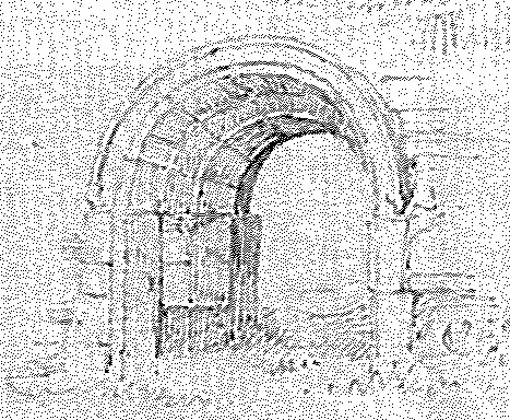
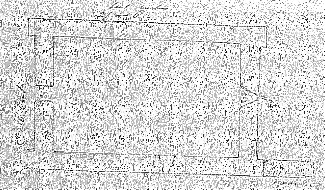
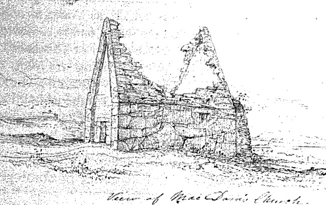
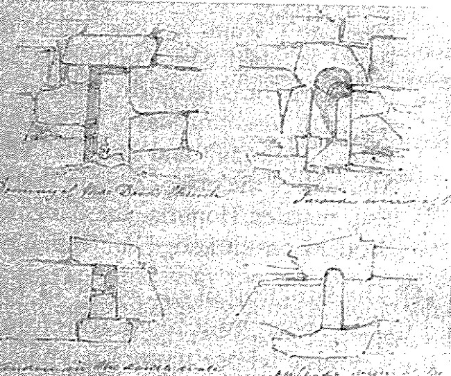
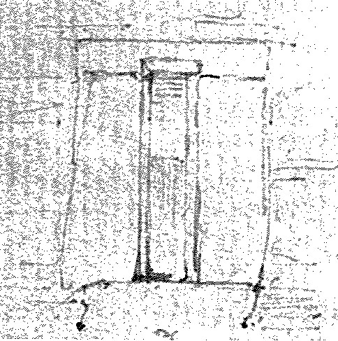
The church of Saint Mac Dara situated on the eastern side of the island, and close to the only sure landing place, is formed of very large stones, and is of most excellent masonry. It had originally a stone roof part of which is yet remaining, and in the eastern gable is a little window of the round form. The window measures in height (on the inside) 4 - 7 and the breadth at the top is 2feet. 2inches. where it is covered with a single stone. The breadth at the bottom is 2feet. 4inches. For further particulars see sketch. [Fig. 109, upper and lower right]
The doorway is placed in the western gable and is the finest specimen of the semi-Cyclopean doorway in this part of the country It. measures in height 5feet. 8inches.; the breadth at the top is 2feet. 2inches. and at the bottom 2feet. 6inches. The lintel is 4 - 6 in length, 1 - 4 in depth and runs the whole thickness or the wall.
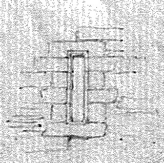
There is a little window in the south side wall, square and 1foot. 7inches. in height but it is now built up.
North of the church, at a distance of about 100yards., there is a square altar with a little broken cross upon it and not far from this is a holy well dedicated to St. Mac Dara, and much venerated by the people of the neighbouring shores.
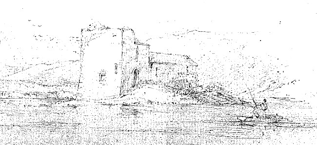
The castle of Ballynahinch is built on a small island {said to be partly artificial} in the western extremity of the lake called by the same name. It consists of a small square tower measuring on the outside 30 feet in length and about 24½ feet in breadth. To the north side is a modern addition built by Col. Martin for a brew house, but at present it is in a most ruinous state, not having been taken care of for many years. W.F.W.
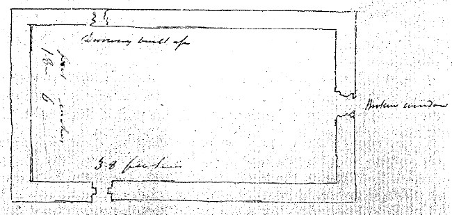
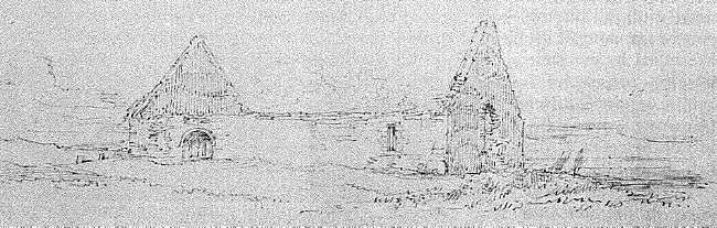
On the south side of the bay immediately opposite Roundstone and close to the sea stands the ruined church of Moyrus. It originally had 2 doorways, but the one on the north side is built up. The one now used is in the south side wall at a distance of about 12 feet from the western gable and is formed of 3 concentric arches the stones of which are beautifully cut. The present height of the doorway is only 4 feet (2 inches), but the earth has been raised several feet, and the breadth 2feet 5inches. The eastern gable contained a fine window, now nearly destroyed.