
OF THE PARISH OF OMEY
Situation. This parish is bounded on the north by the parish of Ballynakill; on the east by the parishes of Ballynakill and Moyrus; on the south by Moyrus and Ballindoon, and on the west by the Atlantic ocean.
Name. The name of this parish is written in the annals of the Four Masters at the year 1017 iomaith; in Pope Nicholas's Taxation 1291; (Immagia by Colgan) Ummy in the Inquisitions taken in the reigns of James I and Charles I, (Imay by O'Flaherty), and Omey in all modern authorities. The meaning of the name has not been explained by any of the Irish writers ancient or modern, nor can any certain interpretation of it be now given. The name is properly that of an island (on) which the great St. Fechin of Fore erected an abbey in the seventh century, and the etymological speculatist, who will stop at nothing, but guess away, rightly and wrongly, is very apt to come to the conclusion that the word is compounded of 1, an island, and maith, good, i.e. insula bona; but this is at best a mere ([Added in pencil:] juxta [?]edam) conjecture though it is acknowledged that its ([Added in pencil:] the) soil ([Added in pencil:] of the land) is good. [Added in pencil: s [?]aith sin! q? iomaidh i. clampar? iomdha .i. slinneáin?]
I shall here transcribe what the learned O'Flaherty wrote about this parish in 1684.
Between Innistuirk(a) and Imay Islands, an arm of the sea runs up by Bally-Mac Conry(b) to the Castle of Doon,(c) where there is a harbour for shipping. The church of Ath dearg(d) near the castle, they say, was in ancient time the parish church of this parish. church is ({now}) at Imay.
[NOTES BY JOHN O'DONOVAN]
(a) Now Inishturk lying to the south of Omey.
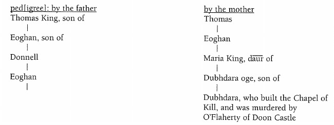
(b) Now called in Irish Baile Mhic Conroi, but anglicised Kingstown. It was so called from a family of Mac Conroi located here about 200 years ago. The name is now anglicised King, but very incorrectly, for Mac Conroi signifies Son of Curoi not son of the King. They were originally chiefs of Gnó-mór (beg) and of the Dalcassian race. See Ped.
(c) This castle is (was) situated on a high rugged rock on the north side of Streamstown bay. Its site is now occupied by the ruins of an old house but (some of) the outer walls of the original castle, four feet in thickness are still traceable.
Seólfaidh mé sios é go bhun chnuic a'duna
Mar bh-fuil caisleán a' phúca thuas air a bhárr.
Mac Sweeny.
The island of Imay lies in the sea, so as on (i.e. at) low water it can be entered dry foot.(e) Within it there is a pool of standing water, and the soil is plain and champaign. St. Fechin erected an abbey therein, but now the parish church is only extant,(f) whereof St. Fechin is patron, the 20th of January worshipped (i.e. venerated), whose well is here visited, which of late proves very miraculous in restoring of health.
[NOTES BY JOHN O'DONOVAN]
(d) [Referred to on MS p. 74] This church is now called Teampull Atha deirg, i.e. the church at the red ford, so named from a small mountain stream (of a reddish colour) which falls into Streamstown bay immediately to the east of it. Its ruins are 40 f. by 20 and the walls are only 3 feet high. It is surrounded by a burial ground, which is still used.
(e) This is perfectly correct, as I have found to my great satisfaction.
(f) This church which seems to have been used in O'Flaherty's time, is 40 f. long and 19 broad on the inside, and its walls are 2f. 9inches. in thickness. It is now nearly buried in the sand. St. Fechin's well which is still held in great veneration, is situated a short distance to the west of it. For the names of the burial places on this island see field name books of the parish of Omey 3, 20, 26, 47. The only feature of this church now remaining is a rude window in the east gable, from which one could safely come to the conclusion that this is not the original church of St. Fechin.
The natives of Connamara, who are now beginning to lay aside their old language, and to speak English, are in the habit of Anglicising (or rather Latinizing) the name of this Saint to Festus, but it bears no analogy whatever with it, for Fechin signifies a little raven, and it is highly probable that he was so called from the color of his hair. "Fiech enim idem est quod Corvus; et Fechin seu rectius Fiechin {sed rectius rectissimè Feichin, JO'D} quod Corvulus." Colgan in Actis Sanctorum, p. 140 Col. 1. note 2.
St. Fechin Abbot, native of Lugny {Leyny} in the County of Sligo, and of the same house of Fothart ({now Faughard}) with St. Bridget of Kildare, was founder of several abbeys, the chief of which are Foure in Westmeath, Easdara {Bellasadare} in Sligo, and Cong. From Easdara he came to Imay {Omey} and his memory is kept in several places in this county. He died of the plague, which, anno 664, began in Ireland the 20th of January after.
In the western ocean beyond Imay three smaller islands appear, viz Cruagh-ar-nimay(g) called by Sir James Ware Insula Cuniculorum(h) for its store of Rabbits {Ware Antiq. Cap. 28 p. 287}. It is a bane to dogs, which die on the spot or soon after coming out. The next is Olen-na-mbrahar,(i) or the Friar's Island. The furthest off is Ard-Olen,(j) the high Island {Colgan 20 Jan. p. 135, cap 22}
[NOTES BY JOHN O'DONOVAN]
(g) This island is now called simply Cruadh, the adjunct here given being totally forgotten, but the most intelligent of the natives whom I consulted about it, are of opinion that ar-nimay must mean air n-aghaidh Iomaighe, e regione Imagiae, i.e. the Cruach or stack or reek lying opposite Imay now Omey.
(h) It still abounds in rabbits, but is no longer a bane to dogs.
(i) You leave this island a short distance to the right as you sail from Streamstown to High island. It is still called Oileán na m-bráthar in Irish and Friar island in English. There is a spot on the north side of Cruagh island called Caibidil na mbrathar, i.e. the chapter of the friars, where, according to tradition, the friars of Illaunnambraher held a Chapter.
(j) Fundavit et vir Dei aliud monasterium in Vicina insula, quae olim Inis Iarthuir hodié ardoilen appellatur.
Acta SS., p. 135.
Haec insula est etiam in oceano, distatque paucis versus occidentem ab Immagià
eamque post S. Fechinum sua anachoresi, et arctissimâ vitâ plurimum nobilitavit S. Gormgalius, vir celebratae sanctitatis, qui obiit anno 1017 die 5. Augusti, quo die juxta Marianum ejus servatur natalis; de cujus encomiis et reliquiis extat paenes (.i. penes) me B, Corrani, que eodem tempore floruit, elegans et piissimum poèma. Vide quatuor Magistros in annalibus ad annum 1017, quo dicunt Beatum Gormgalium Archisinedrum, sive principalem patrem spiritualem totius Hiberniae obiisse.
Id. p. 141, col a note 13.
(k) This description is very accurate; it is very dangerous to attempt climbing up the cliffs of this island in stormy weather.
(l) This well is still in existence, but when I visited it I found it unfit to be used for drink, being black stagnant water. It is surrounded by a little enclosure of loose stones, and now considered a holy (well), for the marines think that Brian Boroimhe was a saint, and not a king.
(m) See ground plan and description of what remains of this large round wall in page 8.
(n) See description and measurements of these cloghans in pages 8, 9.
anciently called Innishiarthar, i.e the west Island. It is inaccessible except on (.i. in) calm settled weather, and so steep that it is hard after landing on it, to climb to the top(k) where there is a well called Brian Boromy {King of Ireland} his well(l) and a standing water on the brook whereof was a mill. There is extant a chapple and a large round wall,(m) and also that kind of stone building called Cloghan,(n) wherein yearly an Eyrie of Hawks is found. Here St. Fechin founded
an abbey as he did at Imay. It is also celebrated for the eremitical retirement of St. Gormgal,(o) a very spiritual person of renowned sanctity who died the 5th of August 1017 and was there interred together with divers other holy hermits that lived with him. Ten of them are named by father Colganus out of an ancient poem in his praise extant {Colg. 21 Mar. Cap. 7. at Vit. S. Endei p. 715 ad finem}.
Northward of Ardolen are Innish-Ark and Bofin, islands of this Country of Conmacny mara in old times, as the same Father Colganus notes, though (but) this country is not part of Irrosdownan as he guesseth(p) {Id. the 1. of March p. 437 numo. 3} but for 300 years past now belonging to the Owles which therefore I (would) omit only (nisi?) that Innisark is of the same property of (as?) Bofin, and the saint therein worshipped was St. Leo, of whose reliques is a bell there extant (there is no account of this bell now, J.O'D.) and that St. Colman, third Bishop of Lindisfarne in England, and native of Connaught as father Colgan
[NOTES BY JOHN O'DONOVAN]
(o) On turning to Colgan pp. 135 and 141 and p. 715 of his Acta Sanctorum I find that he confounds the Ard-Oilean (which lies) to the west of Omey with the Middle Island of Aran, which was also called Ard Oilean. Is it not strange that the learned and acute O'Flaherty was not able to correct this?
(p) Colgan was entirely ignorant of the ancient topography of this part of Ireland. He found that Inis Bofinn was anciently a part of Connamara, and he therefore came to the conclusion that Connamara and Erris were one and the same country! His words are: "Est triplex regio Connaciae olim dicta Conmaicne: una retinens adhuc suum nomen circa Tuamiam, alia Conmaicne Rein, olim, hodié hodie Muinter-Eolais dicta: tertia Conmaicne mhara .i. maritima quae videtur hodié Irros appellari: nam in eâ sitam esse insulam Inis-Bo-finne
appellatam lego". Acta Sanct: p. 437, Life of Boetanus Note 3 on Col. 2. What in the name of common sense was the honest Colgan of Domnach mor Muighe Tachair dreaming about? He read in an old book that the island of Bofin was a part of Conamara, and from this he infers that Con[a]mara was Erris! How did he find out that Inis Bofin was in Erris? The honest John Colgan was only dreaming on this subject, for Inis Bofin was not a part of Erris in Colgan' (his) time; nor at any other period. But in Colgan's time it was, as it is now, a part of Umallia or the Owles, it having been (according to tradition) added to it about 250 years before by an agreement between the Earl of Clanrickard and the O'Mailleys. O'Flaherty was eminently qualified to correct this gross error of Colgan and it gives me great satisfaction to see that he has done so in a modest and becoming manner suitable to his learning and high dignity.
gathers {Tr. Thaum. p. 382 n. 16} arrived at Bofin anno 668 {Ussher de Prim} and there founded an abbey {Ussher de Eccles. Brit. p. 964. Vide Bede Hist. Eccles. L. 4, c. 4} and died the 8th of August 676.
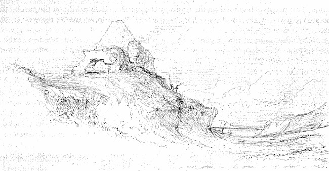
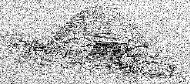
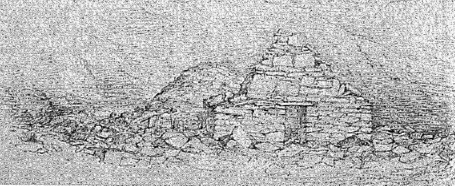
The large round wall mentioned by O'Flaherty as on High Island near Omey is now very much dilapidated. I examined it with the deepest interest to see how far it agrees with those ruins which I had before examined on Inishmurry near Sligo and Inis Glory in Erris, but was very much disappointed at finding it and the little buildings which it encloses in such a (state of) dilapidation state. This wall is like the Caisiols which enclose the little churches and buildings on the two islands already referred to, but it is not so circular as either. It is nearly an (oblong) measuring in length from north to south 38 yards and in breadth from East to West 23 yards. The wall is in many places level with the earth, (especially on the north side), but a few feet of its height remain on the east, south and west sides. Its thickness, as well as I could ascertain from the most perfect part of it near the N.W. corner was about 10 feet {more or less by a few inches}. In the north side of this enclosure, and within about 10 feet of the foundation of the north wall stands a Cloghan or stone house of a character somewhat different from those on Inishmurry or Inishglory. The little houses on these islands are constructed nearly in the form of Beehives but this on Highisland is a beehive (interiorly) squared {if the term be intelligible}. It is 8f. 5in. one way and 8f. 4in. the other, and in height from the present level of the floor to which
is probably a little raised, to the apex, where the building is closed by two stones overlapping each other is 7f. 9inch. Its doorway as it stands at present is very low, but the ground is raised. It is 35 inches broad. The architecture is very smooth on the inside though without cement, but on the outside it looks as irregular as Carn Ceasrach on the summit of Knock Meádha.
On the N.W. side and about 15 feet distant from this cloghan stands another of the same form and characteristics, but of smaller dimensions. It measures on the inside 6feet. 7inches, in length and 5feet. 8inches, in breadth, and from the present level of the floor to the apex, where it is closed by one stone (about 7ft. 6in.). The following sketch will give some idea of the external appearance of the (larger of these) little buildings.
Nearly due west of the larger cloghan, and at the distance of 8f. 0in. from it, is the little chapel of St. Fechin mentioned by O'Flaherty. It measures on the inside 11f. 10inches, in length and 10f. 8inches. in breadth. The east gable is nearly destroyed, but it contains a fragment of a window of this form.
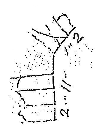
The doorway, as usual in all the old (Irish) churches of the primitive ages, is placed in the middle of the west gable. It is 4f. 5in. in height, 1f. 10in. in width at the top and 2f. 2in. at the bottom, and 2f. 7in. in thickness. The following sketch will give an (accurate) idea of its architecture.
North and by west of this little church there appears to have been another cloghan but (it is now) level with the ground.
There are three doorways or entrances on this external wall, one on the west side, which is 22 inches wide, but its height could not be ascertained without going to great trouble in clearing away the stones; the other in the South-east corner, wch. is 2f. 8in. in breadth, and the third on (near) the north east corner. It is 6f. 0in. wide on the outside and 4f. 3in. on the inside. Immediately to the south of this passage there was another cloghan, which appears from its foundations to have been 15f. 0in. long and 12f. 0in. broad. In the west wall near the south west corner there is a gallery in the thickness of the wall, {now called the Prison} measuring 3f. 9in. in height and 3f. 9in. width, and 21f. 10in. in length. It was originally a little higher but not much as I guess by appearances. It is covered over head with large flags.
North (east) of this enclosure at the distance of a few perches are traceable the foundations of a round building now called the Pound, from an idea that it was used as such by the Saints of the island. It looks of an oval
form, and measures in length 27f., and in breadth 24f. the wall was 5f. 4in. in thickness, but I could form no idea from what remains of what sort of a building it was, or (for) what use it was originally intended. [Added in pencil: Some say that it was a cloghan covered at top with one stone and that it was destroyed by Mr. Martin's Miners.]
There are several penitential stations on this island but I could not learn their names from the people I met on the island. [Added in pencil: See sketches of them on page [?]]
The highest point of this island, on which there is a Trig. Station, commands a varied prospect of sea and land. To the north (and north east) you have a good view of Inis Bofin, Inishark and Achill head, the Ballycroy mountains, Croaghpatrick very much diminished by the distance, the gigantic Mweelray with its two shoulders threatening the clouds; and to the east the twelve Bens of Connamara which Miss Martin calls her 12 pins! To the north east and close to you is Oilean na m-brathar, and East is Cruagh island and beyond it the elevated hill of Rossbeg, and to the South east the flat district of Errismore, the extreme western point of which is called Ceann leime or Slime Head.
The following notice of the islands of Omey and High Island is given in the life of St. Fechin translated from the Irish MS. belong(ing to the Island of Omey) and published by Colgan in his Acta Sanctorum, p. 135 & prae- et seq.
Quadam nocte vir sanctus in Monasterio de Easdara existens, ab angelo in somniis monitus est divinae voluntatis esse, quod accedat ad insulam quadam Oceani, in occidentali regione {12} Connaciae positam, quae Imaidh vocatur: monitis Angelicis paret S. Fechinus, et animo multas animas Christo lucrandi, et monasticum institutum ampliandi, aliquot comitatus discipulis, jam dictam petiit insulam ubi habitare et Ecclesiam Construere proposuit. Sed incolae Diaboli instinctu modis omnibus moliebantur eum excludere, undè ligones, bipennes, serramenta, aliaque instrumenta, quibus ejus Monachi in operae fabricae utebantur, de nocte aliquoties projiciebantur in mare: sed quoties sic projecta sunt, toties ad littus rejecta, mane à Monachis reperta sunt. Sed cum Vir Dei ejus Monachi sic populo renitentente in continuis laboribus, vigiliis et jejuniis persisterent, et plebs in malitiâ induratâ emnem denegaret alimoniam, tandem duo ex fratribus inediâ exhausti
interierant. Hos autem S. Fechinus fusâ pro servis suis oratione ad Dominum in cujus obsequiis sic exhausti interierant, meruit eos ad vitam revocari. Et cum rumor rei gestae ad Regis Guarii filii Colmani perveniret aures, curavit alimoniam in cibo et potu sufficientem ad S. Fechinum deferri: adjecit et suam phialam regiam quae usque in hunc diem Cuach Fechin .i. Phiala S. Fechini appellatur. Post haec Insulani omnes ad Christum Conversi a Sancto Fechino baptizati sunt, et se suamque insulam in usum, et obsequium S. Fechini et successorum consignarunt. Fundavit et vir Dei aliud Monasterium in vicinâ insulâ, quae olim Inis-iarthuir hodie ardoilen appellatur.
Acta SS. p. 135.
Colgan states in note 12 to this life of St. Fechin that an Irish MS. life of the Saint was sent him from the island of Omey. His words are:
12. Ad insulam quandam Oceani nomine Immagiam. c. 22. Haec ex nobili caenobio facta est Ecclesia Parrochialis Dioecesis Tuamensis, in quâ Sanctus Fechinus, ut ecclesiae et insulae patronus in magnâ
habetur veneratione: ex quâ et nos accepimus codicem Hibernicum Vitae S. Fechini, cujus supra in notis ad Sancti Fechini, priorem vitam n. 1. mentionem fecimus.
In describing this (Omey) MS. on page 139, Col. 2, note 1, he says that it contained a diffuse life of St. Fechin, which as its compiler or rather modernizer states was drawn from a Latin life written in the time of St. Adamnan.
Between two inlets of the Atlantic and about 2¼ miles E. by S. of Omey is situated the townland of Ballymaconry now Anglicised Kingstown. It was called after a family of Dalcassian origin, who held this townland under the O'Flahertys till the last wars of Ireland. O'Flaherty speaks of them in his Ogygia as follows:
The Mac Conrys are descended from Gnobeg, who within my recollection held lands in Gno-beg under the O'Flaherties, who for a series of eight hundred years have held the sovereignty of the Conmacnians and Delvinians there.
Part III, c. 82.
In this townland, on the brink of that arm of the Ocean which runs up to Streamstown, and nearly opposite Doon Castle, is a chapel in ruins called by the name of Kill. It
was built, according to tradition by Mac Conry the head of the family from whom the townland took name. The exact period of the erection of this chapel cannot be ascertained but I could infer from the silence of Roderic O'Flaherty (about it) in 1684 that it was not then in existence, and the tradition in the Country is that it was built by Dubhdara Mac Conroi, who lived six generations ago. Thomas King alias Mac Conroi of Kingstown, alias Bally Maconry, is thus descended from him by (on) the mother's side
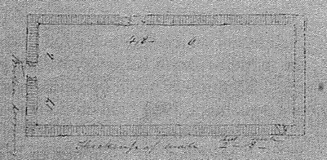
This chapel measures on the inside 48 feet and in breadth 17f. 6in., and its walls are 2f. 8in. in thickness. The east gable is totally destroyed, and the doorway which was in the west gable is reduced to a shapeless breach.
Ground-plan of the old church of Kill (Wakeman)

[MS p. 90 has been left blank]
Mr. Henry Blake of Rinvyle states that he saw on this townland near the Glebe house, the remains of round stone enclosures, which two antiquaries set down as the ruins of the City of Nagnata, the Polis episemos of Ptolemy. I visited the spot, but could neither see nor hear of any such circles. Mr. Blake who believes that Kingstown alludes to a royal City, could believe that there is some truth in this, but I cannot believe that the name Kingstown is of any antiquity, because it was called after a branch of the family of the Mac Conrys who were removed hither by the O'Flaherties from their ancient locality in Gno-Beg.
All these circles have been removed by the progress of cultivation except one, but this is certainly an enclosure
to keep out the cattle from a small enclosure of potatoes. What the others may have been I know not.
John O'Donovan